


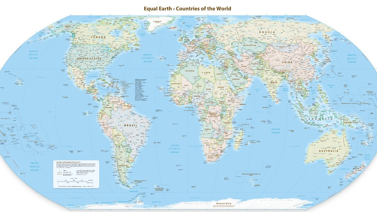

The version of the world map that we have all grown up with was drawn using the 16th-century Mercator projection. Now, the United Nations General Assembly officially voted to move away from this projection in favor of the more accurate Equal Earth projection. This major shift followed a persistent, African-led campaign to address how the world views the actual size of various continents.
Per CNN, the resolution was brought forward by member states of the African Union alongside the Bahamas. The vote saw overwhelming support, with 164 member states voting in favor, while six countries abstained. Only the United States cast a vote against the resolution, with its representative calling the move “superfluous.” Yaryna Ferencevych, the U.S. deputy representative to the U.N. Economic and Social Council, was extremely critical of the initiative.
According to The Washington Post, she described the effort as part of a larger “radical ideological project” that the U.N. is pursuing instead of focusing on “genuine problems of international peace, prosperity, or good relations.” She added, “Resolutions like this and the ideological agenda they promote, are barnacles on our work here, and the reason this institution is losing its credibility.”
An approach for a pre-technology time
The Mercator projection was created by Flemish cartographer Gerardus Mercator in 1569 and was the standard for centuries. The outlet noted that it was originally developed to help sailors navigate the seas using constant compass bearings. However, it came with a major trade-off.
As a result of the way the projection works, landmasses near the equator appear significantly smaller than they really are, while regions further from the equator look disproportionately larger. As noted by The Guardian, this leads to a visual distortion where Greenland appears similar in size to Africa, even though Africa is actually 14 times larger.
The “Correct the Map” campaign, spearheaded by advocacy groups Africa No Filter and Speak Up Africa and backed by the African Union, argues on its website that these distortions have had lasting consequences. The campaign reportedly stated, “For over 450 years, we have based our understanding of Africa, and the world, on a map that is wrong! In fact, you could fit the United States, China, India, Japan, Mexico and much of Europe into Africa and still have land to spare.”
Supporters of the resolution believe that replacing the Mercator projection with the Equal Earth map, introduced in 2018, is a necessary step toward what they call “cognitive justice.” Per CNN, the UN resolution notes “with concern that this distortion contributes to minimizing the perceived sizes of Africa, Latin America and South Asia, and perpetuating an unbalanced view of the world.” It further suggests that these distortions can fuel prejudices in the security, geopolitical, and environmental fields.
The Washington Post reported that Togo’s foreign affairs minister, Robert Dussey, celebrated the vote as a significant moment. Writing on X, he stated, “It is about justice, dignity, equality and the way we represent our world. For too long, inherited cartographic representations have distorted our perception of the true size and place of Africa and other regions of the world. Correcting the map means correcting the way we see the world.”
Before the vote, he also reportedly emphasized that it is about the science. Dussey noted, “This discussion is not a political discussion [but] a scientific discussion, because there is scientific proof so we all have to accept the reality.” Interestingly, as this vote is happening, the UN is currently in the midst of electing its new Secretary-General.
According to The Guardian, the U.N. resolution is non-enforceable, but it encourages schools, governments, and tech companies to adopt the Equal Earth projection. This could lead to real-world changes in how geography is taught in classrooms and how digital platforms present the globe. For instance, Google Maps currently uses a version of the Mercator projection.
During a speech at the Sorbonne University in Paris, France’s foreign affairs minister, Jean-Noël Barrot, announced that the country “will abandon the Mercator projection” in favor of more accurate representations. “The United States, Russia and China take on a disproportionate visual prominence compared to Africa, Latin America or Southeast Asia,” Barrot said, per CNN. He added that “distortions eventually take root in perceptions” and that “the time has come to correct them.”
For those who have advocated for this change, the vote is about more than just cartography. It is about shifting how the world perceives the global south. Amma Twum-Amoah, commissioner for the AU’s Department of Health, Humanitarian Affairs and Social Development, noted, “Africa, once diminished on maps, now insists on being seen at its true scale – geographically, historically, morally, culturally, economically, diplomatically and globally.”








Published: Sep 6, 2026 08:00 am